PC ROUTES:
Penn Central ran in many states in the US. This page is for the purpose of listing each line of the PC per state, including locations, cities, photos, etc.
WESTERN REGION:
-Ohio:
-Carrothers Branch- TOLEDO DIVISION
This line was an ex-PRR line from Toledo (Stanley Yard) to Mansfield, & from there they could go to Orriville, where there was an ex-PRR/PC yard originally. The line was abandoned & torn up from South of Tiffin & on, by CR in the mid to late 1980s.
-(start) MP 90.9 Alexis (Tol. Branch & C&O Xing's)
-MP 89.9 Hallet
-MP 88.4 Boulevard
-MP 87.7 Manhattan
-MP 86.7 Galena
-MP 86.7---Division Post----
-MP 86.4 Buffalo St.
-MP 85.7 Olive
-MP 84.0 Spring
-MP 83.6 CP Maumee
-MP 82.7 Andrus Rd.
-MP 81.7 Outer Yd.
-MP 80.5 Walbridge
-MP 70.0 Lime
-MP 68.6 Woodville
-MP 67.6 Hydrate
-MP 63.4 Gibsonburg
-MP 60.0 Helena
-MP 57.9 Millersville
-MP 54.5 Burgoon
-MP 52.7 Bettsville
-MP 50.8 Maple Grove
-MP 44.5 Coleman
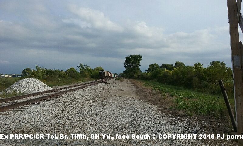
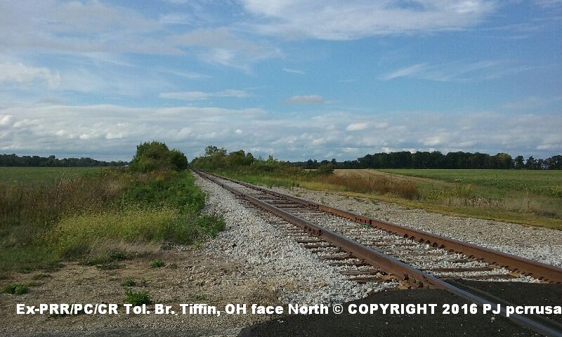
-MP 43.1 Tiffin Photo of ROW & Tiffin Yard, near North of Tiffin, OH, facing South, CR 48, Photo of ROW near North of Tiffin, OH, facing North, near North of Tiffin Yd., CR 48
-MP 33.3 Bloomville
-MP 27.1 N. Carrothers
------MP 76.6 Carrothers-----
-MP 73.7 Chatfield
-MP 69.6 Ridgeton
-MP 65.8 Benson
-MP 63.8 Holmes
-MP 62.8 Colsan
____________________________________________________________________________
WESTERN REGION:
-Ohio:
-Norwalk Branch- - TOLEDO DIVISION:
This was the ex-NYC (and ex-Lake Shore & Michigan Southern- LS&MS) line that connected to the East/West NYC Water Level Route in Elyria, OH, went West and connected back to the Water Level Route at Millbury Junction, OH. This route was used by the PC until around 1976, and was abandoned by Conrail. Most of the line was ripped up in the early 1980s. The ROW is now part of a public bike trail- part of the line is still in and used by NS in Fremont. Part of the tracks were connected to the N&W (ex-NKP/W&LE) in the 1970s, to service the Purina mill that was along this PC line in Bellevue-the mill was serviced up until 1990s by NS- the mill is now gone. A source mentioned before they remembered seeing an NYC F unit or switcher that was parked in idle at PC's Bellevue mill siding/yard, (and the locomotive let off a loud air purge, which scared his young son in the process). The same source remembered while getting a haircut at a barber shop that was in a yellow brick building that sat right next to the tracks on Main St. in Clyde, seeing an EB NYC/PC passenger train go through town with NYC E units. Supposedly the train was accidentally routed through Clyde, because someone had the switch at Millbury Jct. mistakenly aligned for this line, and either a few PC/NYC employees got fired, or at least got an earful as a result. Tracks were still in and used by CR from Elmore to Millbury Jct. as late as 1980s. 20 mph was the speed restriction for this whole line- slower at MP 212-220, all grade crossings at Norwalk, 1 at Monroeville, Bellevue East Yard Limit, MP 250-259, 1 street at Clyde, & 3 Streets at Fremont (as noted in a PC 1973 Western Region TT).
(Going East to West)
-MP 208.9 (Start) Elyria Jct. (with Water Level Route & B&O Xing/Wye- Stop Sign- stop before crossing)
(-MP 208 -600 ft East of MP- Yard Limit Point)
-MP 216.9 Oberlin
(-MP 217 -1034 ft W of MP- Yard Limit Point)
-MP 221.5 Kipton
-MP 226.8 Wakeman
-MP 231.5 Collins
(-MP 236 -900 ft W of MP- Yard Limit)
-MP 238.1 Norwalk (40 car siding both East and West)
(-MP 239 -1900 ft W of MP- Yard Limit)
-MP 242.6 Monroeville (B&O and N&W-ex NKP/W&LE Xing)
(-MP 249 -2175 ft E of MP- Yard Limit)
-MP 250.0 Bellevue (N&W-ex NKP Xing)
-MP 250.1 Bellevue Station (46 car siding both East and West. Original NYC Depot was torn down before PC-most likely. Ex-freight house still exists.)
(-MP 252 -2250 ft E of MP- Yard Limit)
(-MP 257 -2600 ft E of MP- Yard Limit)
-MP 257.5 Clyde (PC-ex NYC-ex CCC&STL- Southern Region Sandusky Branch Xing- Stop Signs & Target Signal-Verticle- Proceed-operated by trainman. 55 car siding both East and West. Depot torn down before PC?)
(-MP 258 -1640 ft W of MP- Yard Limit)
(-MP 265 -1930 ft W of MP- Yard Limit)
-MP 265.9 Fremont (N&W-ex NKP/W&LE Xing- Target Signal-Verticle- Proceed-operated by trainman. 52 car siding both East and West)
(-MP 268 -400 ft E of MP- Yard Limit)
-MP 273.0 Lindsey
-MP 278.2 Elmore (36 car siding both East and West. Ex-NYC Depot still exists.)
(-MP 281 -171 ft W of MP- Yard Limit)
-MP 283.0 Genoa (48 car siding both East and West)
(-MP 287 -3650 ft W of MP- Yard Limit)
-MP 287.6 Millbury Jct. (with Water Level Route. 26 car siding both East and West)
-Grade Crossing Info:
Following road crossings on all tracks (unless otherwise noted)- trains must stop before crossing, proceed when clear, while protecting crossing- at the following streets:
*Norwalk- Prospect, Milan, Foster, Wooster, Whittlesey
*Monroeville- (Main track) Rt 547/W. Monroe
*Bellevue- Monroe
*Clyde
*Fremont- Crogan, Napoleon, Garrison, Birchard, Hayes
______________________________________________________________________
SOUTHERN REGION:
A very reliable source witnessed the NYC pulling up track not that far North of Clyde on State Route 101, where the track crossed, in the Fall of 1967, while traveling on a family trip with his parents. He saw a yellow NYC truck-crane parked next to the tracks, and saw piles of ties and track in the process of being hauled out. This is the line where the PC local with a GP-7 or 9 and a few boxcars jumped the end of the tracks heading North, just North of the mill in Clyde, and into the field around April of 1972 or so. They had to attach another PC GP-7 or 9 to the other end of the train to pull the locomotive back onto the tracks. The tracks were still in from Clyde and South, but totally abandoned in the late 1970s and possibly the early 1980s, when most of the tracks were torn up in most areas. In Carey, the tracks are still in, and used by CSX and the quarry near town. South of that, the line may still be in tact in some areas. Some of the old ROW has been re-developed with houses or buildings built on top, whether parts of the ROW was either sold or just taken over. But in other areas, the ROW is still in tact. A lot of the ROW was elevated South of Tiffin to Carey. From another good source, NYC and PC would tend to use Baldwin S switchers (such as an S-2) for their locals on the line, and at least at one point, they tried using a GP-7 or 9, and ended up spreading the rails and derailing, because of bad track or because of using a heavier locomotive. Once such derailment happened near Galetown/Galetown Road, or outside of Green Springs. Since the abandonment, country roads that crossed the ROW have been lowered below the old ROW's original elevated level. Most of this line was considered "dark territory", meaning no signals were used, just train forms. Signals however were used before (constant Approach-amber signal for a crossover ahead), and a stop-red at crossovers. It would be great if Rails-To-Trails turned this ROW into a trail for preservation the correct way. Also PC had abandoned the line between Sands and Belle Center. Then it continued from Belle Center to Bellfontaine, then called the Belle Center running track. From there on South it was called the Springfield Branch, all part of the original Secondary Big Four CCC&STL line.
-Ohio:
-Sandusky Branch- COLUMBUS DIVISION:
This was the ex-NYC "Big Four" CCC&STL Secondary Branch that originally ran from the Sandusky, Ohio pier, South through Kenton, Springfield, Xenia, and to Cincinnati. Around 1967, the NYC had taken out, or at least abandoned the line from Sandusky, to North of Clyde [however, PC lists in a Western Region 1973 TT instructions of using "Southern Region Main Track between a location 400 ft north of CP242 (Water Level Route) and Decatur St. on Pier Branch", and also lists the Sandusky PC Pier track in Water St., between Franklin & Hancock Streets, used jointly by PC, B&O/C&O], and the section between Clyde and Berwick was up for abandonment in 1972, but still being used. They still used the line with a local train that serviced Tiffin, Carey, Kenton, (Clyde from the PC Toledo Branch) etc. until about 1975 or so. PC Southern Region Timetables as late as 1976 still list the line (less to Sandusky).
-MP (Start) Sandusky - in Water St., near Lake Erie
-MP Castalia (there was a branch line that came off this line to a stone quarry which is now a national park area off State Rt. 101, just West of Castalia.)
--------------------------------------------(by 1976, PC omitted the listing of the line from Sandusky to Clyde in their TT. Speed limit between Berwick and Clyde is 10 mph per TT.)
-MP 17.0 Clyde (crossed PC Toledo Branch downtown, and N&W Toledo/Pittsburgh Division. NYC/PC serviced at least 2 lumber companies and at least 2 elevators in Clyde. The line crossed State Rt. 101 twice, Rt. 20, Main St., Maple St., followed along the South side of Maple St. in Clyde several blocks, then crossed Raccoon Creek, Race St., Woodland Ave., Limerick Rd., Galetown Rd., then South towards Green Springs.)
-MP 22.7 Green Springs (crossed the double main N&W-NKP Fort Wayne Div. line) an N&W tower was at this location
-MP Watson
-MP 32.4 B&O Chicago Line double main and PC Carrothers Branch Crossings (technically Tiffin- near Tiffin Tower)
-MP 34 Tiffin
-MP 42.7 Berwick (crossed PC TOC line through Findlay to Toledo)
------MP 42.8 Eastern Branch Connection where PC EASTERN BRANCH begins:-----
-MP 45.3 Adrian
-MP 48.5 crossed the C&O Columbus Sub couble main line, the AC&Y line, and had a depot there that still exists, but is used as something else- technically Carey)
-MP 49.7 Carey
-MP 57.3 Wharton (had a depot there originally)
-MP 62.2 Forest (PC tower at this crossover of Pittsburgh-Bucyrus Division)
-MP 63.9 Patterson
-MP 65.5 McVittys
-MP 68.4 Grants
-MP 74.1 Kenton (Western Branch Conn., Sands Industrial Track)
-MP 74.7 Sands -Erie Crossing (this line ended here by the PC in 1971- it technically started again at Belle Center)
----------------------------
-MP Belle Center
-MP Bellfontane (as PC named it although it's Bellfontaine- crossed the other Big Four PC line to Berea/Cleveland, connected to the St. Mary's Branch, and Springfield Branch- Springfield Branch being part of the original all part of the Secondary Big Four CCC&STL)
Photo of ROW near Carey, facing South (Most of the ROW in that area was built up high.)
______________________________________________________________________
(more to follow)
*Railroad BLOG of Past & Present [For more PC route information on a Railroad Blog of past & present, full of informative Railroad topics, inluding the PC, CR, past & present railroads & railroad topics, fro 1-West ProductionsÖ]
Click For Further Details About the PC
Back To PC Short Overview Page
(Or please use your Back button on your browser to go back)
(C)®2012-2016-2019 Copyright pcrrusa Duplication of this page and of the information on it is prohibited by law, without permission first from the website author/owner.